With Terra Map it is possible to record all the important information of your trips, share them with others and import external tracks to be used as reference.
Track recording
To start recording your Track, tap on this button ![]() , it will start recording the track and the button will change
, it will start recording the track and the button will change ![]() , tap again to pause or to stop and save the track. In case you pause the track, tapping again will restart the track recording.
, tap again to pause or to stop and save the track. In case you pause the track, tapping again will restart the track recording.
NOTE: all the markers and photos inserted while recording a track will be automatically "linked" to the track. When you will share the track you will have the option to share the track together with all the linked markers and photos.
NOTE: if you are using the free version of the app (you have not purchased the PRO subscriotion) you can only save up to 3 tracks.
Track info box
When the app is recording a track, a new section of information will be added to the GPS info box:

This new section of the window contains (from left to right):
- the Total Length of the recorded track,
- the Average Speed of the recorded track,
- the Total Time of the recorded track.
NOTE: tapping on this info box will open the corresponding Track info page.
Track popup
You can access information about a track by tapping on any point along the track. It will open a pop-up window  where you will be able to share it
 ![]() or access its "info" page
or access its "info" page ![]() .
.
You can also access the same page from the Search page.
The popup window shows:
- on the first row: the name of the Track ("Pocol_cut")
- on the second row: the distance and direction of the tapped point compared to your GPS position ("26°T - 205 mi"),
- on the third row: the altitude ("1274", if available in the track data) and the time and date of the tapped point along the track ("25/08/22 16:33:00").
NOTE: tapping on the track name in the center of this dialog (or any similar pop-up) will open a page with the list of all objects near that position. See the Map information page for more details.
Track info page
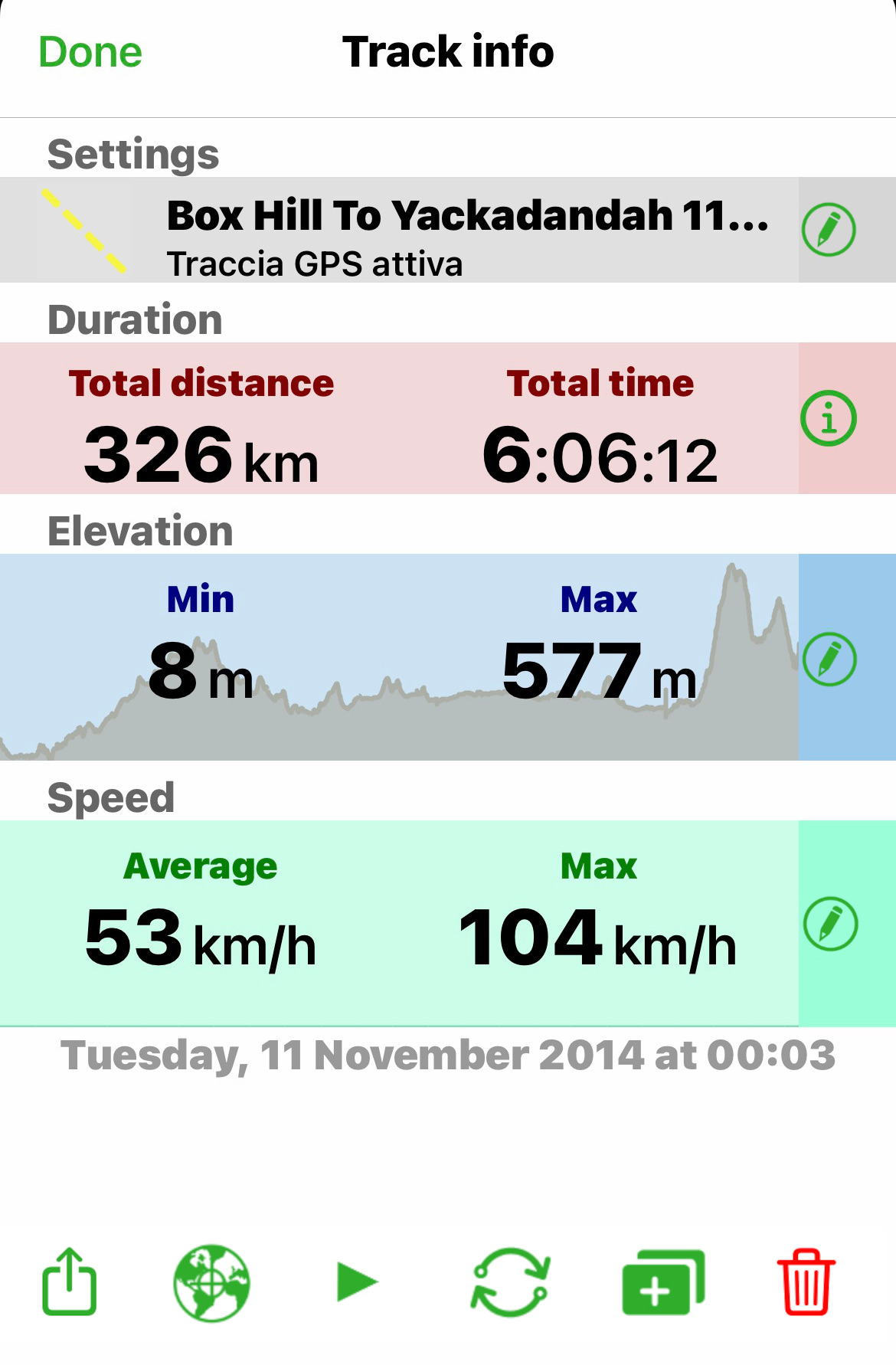
The below image is the track "info" page, where you will be able to:

- open the Track settings page (tap on the corresponding
 button), where you can edit name, description, color and visibility of the track;
 - open the Duration page (tap on the corresponding
 button), where you see the main info regarding the track (total distance and total time);
 - open the Altitude page (tap on the corresponding
 button), where you see the Altitude graph and main altitude info.
NOTE: in case the track does not have any altitude info associated with, this section will not be present.
NOTE: in the Altitude page it will be possible to delete portion of the track. - open the Speed page (tap on the corresponding
 button), where you see the Speed graph and main speed info.
NOTE: in case the track does not have any speed info associated with, this section will not be present.
NOTE: in the Speed page it will be possible to delete portion of the track.
From the bottom menu you can:
- share
 the track in GPX or KMZ format. You will be able to share in many different ways (eg GEC Account, eMail, other apps, ...). See the sharing page for more details;
 - center the map
 on the track, will close this page and will zoom on the map centered on the track.
NOTE: this button on the Altitude and Speed graph pages will center the map on the track exactly on the point corresponding to the slider selection on the graph. - follow
 the track, will make this track "active" to allow you to follow it like a tour. If the track is active, this button will be substituted by the
  button that will stop the track navigation.
When following a track you will get the same behaviour and info that you have when following a tour.
NOTE: Following a track will create dummy (automatically calculated) waypoints along the track itself, in order to help with some references during the navigation. - reverse
 the track, will reverse the track direction (start becomes end and viceversa). All the track info will be recalculated considering the new direction.
NOTE: This button is not active if you are following or recording the track. - duplicate
 the track, will create a new track with the same content of this one. The new track color is automatically changed to white.
NOTE: This button is not active if you are following or recording the track. - delete
 the track
Track duration page
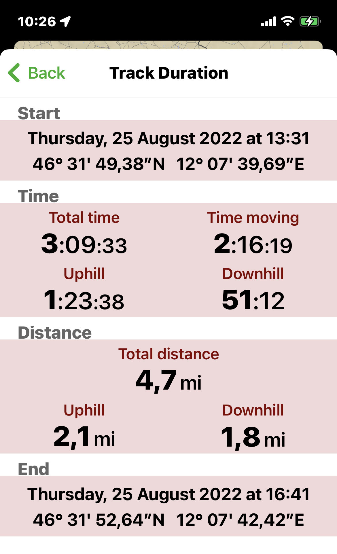
In this page you can see the main track information.
 The fields represent:
- Start: date, time and precise coordinate of the track starting point.
NOTE: in case you invert the track, the start and end coordinates are inverted but the start and end time are not inverted. - Time: the main info related to the time duration of the track:
- Total time: is the total time duration of the track (so the difference in time between the first and the last point).
- Time moving: is the time you were effectively moving, so the total time minus the stop you did along the track (very short stop are not taken in consideration).
- Uphill: is the actual movement time spent uphill.
- Downhill: is the actual movement time spent downhill.
- Distance: the main info related to the length of the track:
- Total distance: is the total length of the track.
NOTE: many GPS trackers calculate the length of the track in 2D, Terra Map calculates the length of the track in 3D. So, if you are moving with an high slope, you can see differences in the calculation done compared to standard GPS trackers. - Uphill: is the length of the track done while you were moving uphill.
- Downhill: is the length of the track done while you were moving downhill.
- Total distance: is the total length of the track.
- End: date, time and precise coordinate of the track ending point.
NOTE: in case you invert the track, the start and end coordinates are inverted but the start and end time are not inverted.
Track elevation page
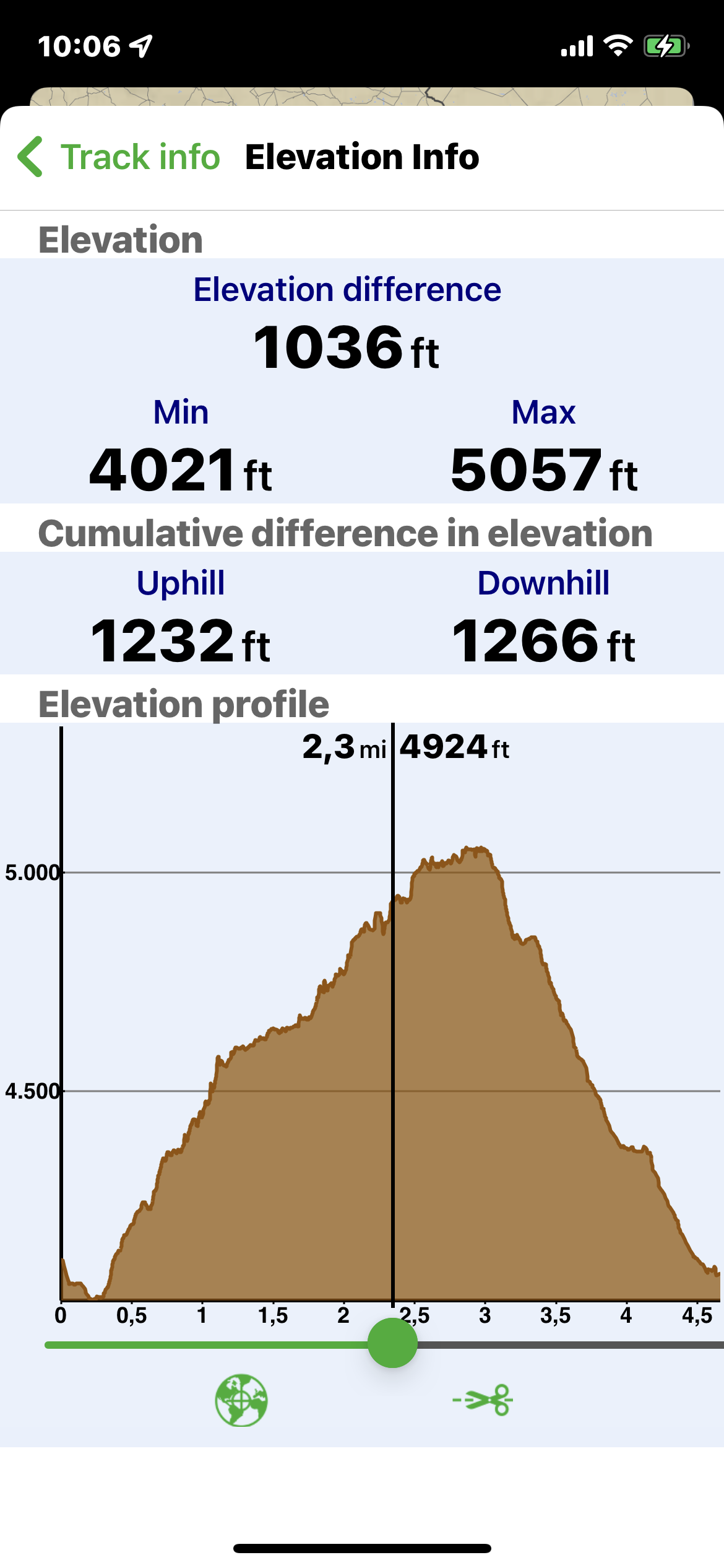
In this page you can see the information related to the altitude of the GPS along the track:
NOTE: the quality of the data displayed in this page is highly dependent on the quality of the GPS signal along the track. To have reliable info you should try to always have a good (green) GPS quality (see GPS page for more info).

The fields represent:
- Elevation: the main info related to the altitude of the GPS along the track:
- Elevation difference: is the difference between the Min and the Max altitude reached along the track,
- Min: is the minimum altitude along the track.
- Max: is the maximum altitude along the track.
- Cumulative difference in elevation: this is the sum of all the small altitude differences along the track.
- Uphill: this is the sum of all the differences done while moving uphill.
- Downhill: this is the sum of all the differences done while moving downhill.
- Elevation profile: this is the graph of the altitude along the track.
You can zoom and pan on the graph; you can also move the cursor so to have the exact distance (from the beginning) and altitude of each point along the track.
From the bottom menu you can:
- center the map
 on the track at the exact point corresponding to the graph cursor.
 - cut
 the track, from the graph cursor to the end (or the beginning) of the track. The selected portion of the track will be deleted and all the track info will be recalculated.
NOTE: pay attention, you cannot undo this operation, so we suggest to duplicate the Track before to do this operation.
Track speed page
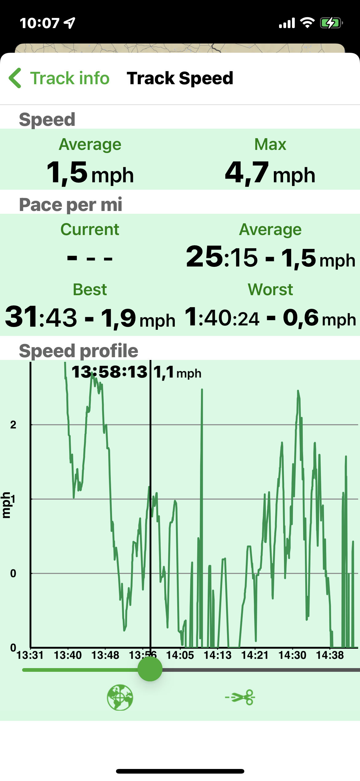
In this page you can see the track information related to the speed.

The fields represent:
- Speed: the main info related to the your speed along the track:
- Average: is the average speed you had along the track. The calculation is simply the total length/ the total time. This means that if you stop along the track your average speed will be impacted.
- Max: this is the fastest speed you had along the track.
- Pace per mi: this section contains the Pace info. The Pace is similar to the speed but it is averaged in 1 mi, so all the Pace info are referred to a 1 mi distance.
- Current: is the average speed you had in the last mi.
NOTE: this field is present only meanwhile you are recording the track. - Average: this is the average Pace you had along the track.
- Best: is the best Pace (so the fastest 1 mi) you had along the track.
- Worst: is the worst Pace (so the slowest 1 mi) you had along the track.
- Current: is the average speed you had in the last mi.
- Speed profile: this is the graph of the speed along the track.
You can zoom and pan on the graph; you can also move the cursor so to have the exact time and speed of each point along the track.
From the bottom menu you can:
- center the map
 on the track at the exact point corresponding to the graph cursor.
 - cut
 the track, from the graph cursor to the end (or the beginning) of the track. The selected portion of the track will be deleted and all the track info will be recalculated.
NOTE: pay attention, you cannot undo this operation, so we suggest to duplicate the Track before to do this operation.
Track editing
This is a summary of all the possible changes you can do to a Track.
- change the name: from the Track info page, tap on the
 button in the Settings section, then select the Track name field.
 - change the description: from the Track info page, tap on the
 button in the Settings section, then select the Track description field.
 - change the color: from the Track info page, tap on the
 button in the Settings section, then select the preferred color.
 - hide/show in the map:
- from the Track info page, tap on the
 button in the Settings section, then tap on the Hide/Show switch,
 - from the Search page, tap on the icon on the left of the track row.,
- from the Track info page, tap on the
- cut the track:
- from the Altitude and Speed graph pages (see above), select the cutting point with the slider and then tapping the
 button. You will be asked if you would cut the track from that point to the end or to the beginning,
 - from the map, tap on the cutting point, then open the Track info page with the
 button, open the Altitude or the Speed graph page, the cursor will be placed at the exact location where you tapped on the track, tap the
  button.
- from the Altitude and Speed graph pages (see above), select the cutting point with the slider and then tapping the


